PHOTOMOD
PHOTOMOD is a professional digital photogrammetry system for turning aerial, UAV, and satellite imagery into orthophotos, terrain and surface models, 3D mode…
What PHOTOMOD is
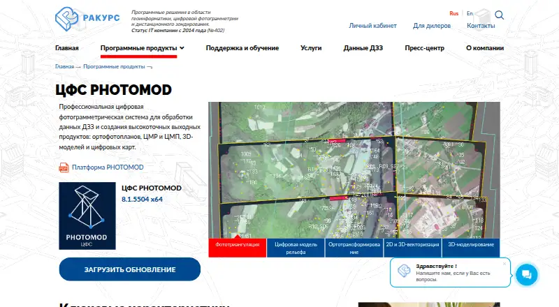
PHOTOMOD is a professional digital photogrammetry system for turning aerial, UAV, and satellite imagery into orthophotos, terrain and surface models, 3D models, and digital maps. Its workflow spans preparing input, triangulation, modeling, orthotransformation, vectorization, and 3D work. Distributed processing and GPU support are available to improve performance, and a broad set of exchange formats supports work with other photogrammetry and geographic information systems. Deployment options include a local workstation, a distributed network, and the GeoCloud service or rental. Supported systems listed by the maker include Windows 8.1/10/11 x64 and several Linux distributions. Local use requires a USB hardware protection key; network use requires a local network connection. PHOTOMOD is configurable for individual specialists and larger mapping teams. The pricing information lists PHOTOMOD Core local at 125,000 RUB, paid once and network at 175,000 RUB, paid once; full suites are 1,103,000 RUB, paid once locally or 1,373,000 RUB, paid once on a network. The listed free plan is unavailable.
Good
- Processes aerial, UAV, and satellite imagery.
- Produces orthophotos, models, and digital maps.
- Supports distributed processing and GPUs.
- Exports orthophotos, point clouds, and GIS data.
- Offers local, network, and GeoCloud deployment.
Watch out
- Local version requires a USB protection key.
- Network version requires a local network connection.
- Linux Core license costs 50% more than Windows.
- UAS package limits image size to 100 megapixels.
Who it suits
PHOTOMOD suits specialists and mapping production teams processing aerial, UAV, or satellite imagery. Its local and network deployment options accommodate different work setups.
Verdict
PHOTOMOD covers a broad photogrammetry workflow, with output and deployment options for individual specialists or larger teams. Buyers should account for the hardware-key or network requirements and the listed one-time license prices.
Plans and prices
From PHOTOMOD's own pricing page, checked 20 Sep 2026.
| Plan | Price | What it gives you |
|---|---|---|
| PHOTOMOD Lite | Priced on request | 40 central-projection images · 2 space-scanner images · 50 MPix output orthophoto |
| PHOTOMOD GeoCalculator Pro | Priced on request | Coordinate conversion · Transformation and datum parameter calculation · Web-map window |
| PHOTOMOD AutoUAS | Priced on request | Central-projection JPEG images · Images up to 100 MP |
| PHOTOMOD UAS | Priced on request | Images up to 100 MP |
| Full local PHOTOMOD package | Priced on request | Up to 20 CPU cores for distributed processing without DiPro |
| PHOTOMOD Core (local license) | 125,000 RUB, paid once | project setup and management · Windows license pricing · Linux license costs 50% more and includes Windows |
| PHOTOMOD Core (network license) | 175,000 RUB, paid once | network use · Windows license pricing · Linux license costs 50% more and includes Windows |
| Full local PHOTOMOD suite | 1,103,000 RUB, paid once | Windows 8.1/10/11 x64 or listed Linux distributions · one computer with the hardware protection key · up to 20 processing cores before additional DiPro licenses |
| Full network PHOTOMOD suite | 1,373,000 RUB, paid once | Windows or listed Linux distributions · network key · concurrent use limited by the number of paid module instances |
The facts
Each one read from PHOTOMOD's own pages, with the date it was checked.
What it does
- Deployment
- PHOTOMOD is available as a local workstation, a distributed network environment, and through the GeoCloud service or rental.checked 3 Oct 2026
- Input data
- The system supports professional aerial photography, UAV imagery, and satellite imagery.checked 3 Oct 2026
- Intended users
- The maker describes PHOTOMOD as configurable for individual specialists as well as larger mapping production teams.checked 3 Oct 2026
- Interoperability
- The product supports a broad set of exchange formats for compatibility with other photogrammetry and geographic information systems.checked 3 Oct 2026
- License protection
- The local version requires a USB hardware protection key, while the network version requires connection to a local network.checked 3 Oct 2026
- Notable limit
- The separately priced PHOTOMOD UAS package limits image size to 100 megapixels.checked 3 Oct 2026
- Operating systems
- The maker lists Windows 8.1/10/11 x64, Astra Linux 1.7.x/1.8.x, ALT Linux 10.4, RED OS 8.0, and AlterOS 9.6 as supported operating systems.checked 3 Oct 2026
- Processing
- PHOTOMOD supports distributed processing and use of GPUs to improve performance.checked 3 Oct 2026
- Purpose
- PHOTOMOD is a professional digital photogrammetry system for processing remote sensing data and producing orthophotos, terrain and surface models, 3D models, and digital maps.checked 3 Oct 2026
- Security credentials
- The maker lists Russian software registry registration and states that JSC Racurs holds a Ministry of Defense of Russia license for work related to creating information protection tools.checked 3 Oct 2026
- Support
- The software price includes one year of technical support, including a three-hour introduction, phone, online and in-person consultations, and version updates.checked 3 Oct 2026
- Support renewal
- After the included support period, renewing support for one year costs 20% of the current software configuration price.checked 3 Oct 2026
- Workflow
- Its photogrammetric workflow covers input preparation, triangulation, terrain and surface modeling, orthotransformation, 2D/3D vectorization, and 3D modeling.checked 3 Oct 2026
The company
- Founded
- 1993checked 28 Sep 2026
- Headquarters
- Moscow, Russiachecked 28 Sep 2026
Alternatives to PHOTOMOD
- 1

Felt
Free planAndroidiOSWebAPI8.2From $199 a month - 2
NASA WorldWind
Free planOpen sourceAndroidWebAPILinux7.9Free plan - 3

Maptitude
AndroidiOSWebAPI7.8From $795 a year - 4
Mapbox Studio
Free planAndroidiOSWebAPI7.7Free plan - 5
StatSilk
Free planAndroidiOSWebAPI7.7From $495 a year - 6

GIS Cloud
Free planAndroidiOSWebAPI7.5From $5 a month