Vizumap
The facts below are what the maker publishes about Vizumap, checked and dated. Our editors have not written about it yet.
The facts
Each one read from Vizumap's own pages, with the date it was checked.
What it does
- Animated maps
- Pixel maps can be animated across sampled values; areas with high uncertainty flicker more visibly than areas with low uncertainty.checked 12 Oct 2026
- Animation
- Pixel maps can be animated, with high uncertainty appearing as visible flickering and low uncertainty appearing almost static.checked 12 Oct 2026
- Bivariate maps
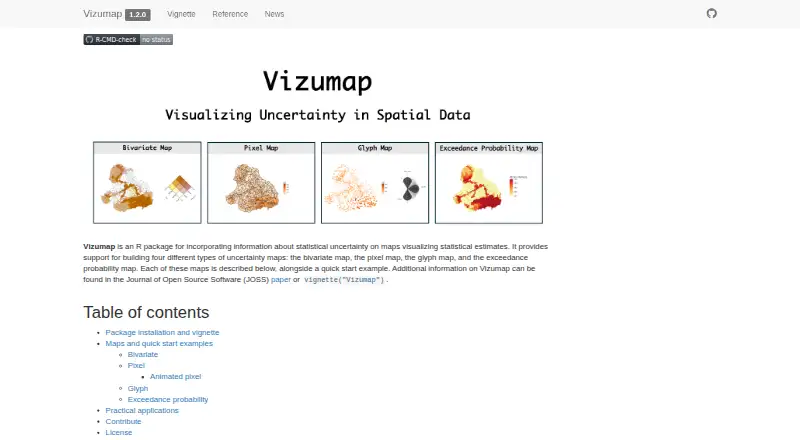
- Bivariate maps blend colors for estimates and uncertainty into a 3×3 color grid, with each geographic area shown in one color.checked 12 Oct 2026
- Citation
- The makers ask users who make or publish a map with Vizumap to cite Lucchesi et al. (2021), published in the Journal of Open Source Software.checked 12 Oct 2026
- Contributions
- The project provides contribution guidelines and a Contributor Code of Conduct.checked 12 Oct 2026
- Data sources
- Data frames and geographic data including shapefiles; bundled Burdekin example datachecked 23 Sep 2026
- Example audience
- The site describes communicating pollutant predictions and uncertainties to catchment managers and policy makers as a use for Vizumap.checked 12 Oct 2026
- Example data
- The package includes example data on predicted total suspended sediment loads and prediction uncertainties from Queensland’s upper Burdekin catchment.checked 12 Oct 2026
- Exceedance maps
- Exceedance probability maps color each geographic area according to the probability of exceeding a specified threshold or target.checked 12 Oct 2026
- Glyph maps
- Glyph maps use color for the estimate and rotation for uncertainty, placing equally sized glyphs at geographic-area centroids to give areas equal visual attention.checked 12 Oct 2026
- Installation
- The site provides an installation command using remotes::install_github() for the lydialucchesi/Vizumap repository and instructions to open the package vignette in R.checked 12 Oct 2026
- Integration
- The pixel map quick start loads the R package sf and uses its sf_use_s2 function.checked 12 Oct 2026
- Intended users
- The site says its maps can communicate pollutant predictions and uncertainties to catchment managers and policy makers.checked 12 Oct 2026
- License
- The site identifies Vizumap version 1.2.0 as licensed under GPLv3.checked 12 Oct 2026
- Map types
- It supports bivariate, pixel, glyph, and exceedance probability maps.checked 12 Oct 2026
- Pixel maps
- Pixel maps assign values sampled from an estimate’s confidence or credible interval to small pixels within geographic areas; higher uncertainty appears more pixelated.checked 12 Oct 2026
- Product
- Vizumap is an R package for showing statistical uncertainty on maps of statistical estimates.checked 12 Oct 2026
- Purpose
- Vizumap is an R package for adding statistical uncertainty information to maps of statistical estimates.checked 12 Oct 2026
- Scheduled refresh
- Nochecked 23 Sep 2026
Where it runs
- Applications
- The site lists published applications involving Australian plague locust abundance, child undernutrition in Bangladesh, and cropland productivity and shipping activity in Ukraine.checked 12 Oct 2026
Money
- Free plan
- Yeschecked 23 Sep 2026